3D laserskening


List of sites scanned within the framework of our company / Links
A revolution similar to that one, which occurred a certain time ago in geodesy in form of a massive use of laser telemeters, computer technique or GPS we experience again today, thanks to introduction of new scanning technologies. So-called 3D Laserscan is the essential milestone as well in documentation in the field of preservation of historical monuments. In the Czech Republic 3D Laserscan was tested for the first time at an archaeological excavation in 2003 by the company GEODIS a.s., at the excavations in the Panská St. in Brno. The application of this device in terrain we take for the biggest revolution in documenting historical monuments and archaeological finds within past decades.
About laserscanning
- Laserscanning is a modern method of making exact documentation of spatially complicated objects like facades of historical buildings, industrial services and devices, constructions or underground spaces and tunnels.
- Main advantages of laserscanning are: high density of measured data within a short time span, possibility of use also under a low visibility and high precision of acquired data.
- The ray precision does 5 – 20 mm.
- The laser data can be supplemented by the data acquired through a digicam and the output then can be some very realistic spatial visualisations of measured objects.
Application of 3D Laserscan at the projects of our company
Almost two years of cooperation with the company GEODIS a.s. showed above all the possibilities of this fully revolutionary form of documentation. For the time being there are total 10 sites scanned – mainly the finds within the framework of archaeological excavations, cellar rooms and in one case also a part of a castle. Considering the expensive software and hardware intended for the processing of scans, we regard these first attempts above all as an investment into the future when it will be simpler to evaluate the data, particularly in case of the sites scanned are already not existing. With further computer processing we mean e. g. a conversion into CAD (for example Microstation) and thereafter making of drafts, sections, ground plans, projections etc. In the field of historical monuments the 3D Scan represents also a unique basis for the reconstruction and modelling of already not existing objects (burgher houses, gates, defence walls, castles etc.). Completely idle are today the possibilities in the field of popularisation of archaeology and historical monuments at all. Therefore the company Archaia Brno wants henceforth to be engaged in further use and methodics of processing in the field of preservation of historical monuments.
List of sites scanned within the framework of our company
Excavations in Brno: Pánská, Česká 10, Zelný trh 17, Kopečná 43, Jakubské náměstí - kostel sv. Jakuba, Moravské náměstí 6,
Moravské náměstí park - pozdněgotická brána, Božetěchova FEI VUT v Králově poli
Actions outside of Brno: Lipnice nad Sázavou, Náměstí republiky v Praze
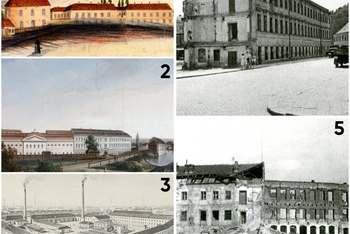
Brno, Polyfunkční komplex Dornych: Offermannova továrna
10. 07. 2026 – Aneta Krejčířová – David Zima – zobrazit
V předchozím příspěvku o záchranném archeologickém
výzkumu v areálu budoucího polyfunkčního komplexu Dornych padla
zmínka o industriálním dědictví. Zkoumanou plochu výrazně proměnila
Offermannova továrna na vlněná sukna a železniční spojka z hlavního
nádraží na dolní nádraží...